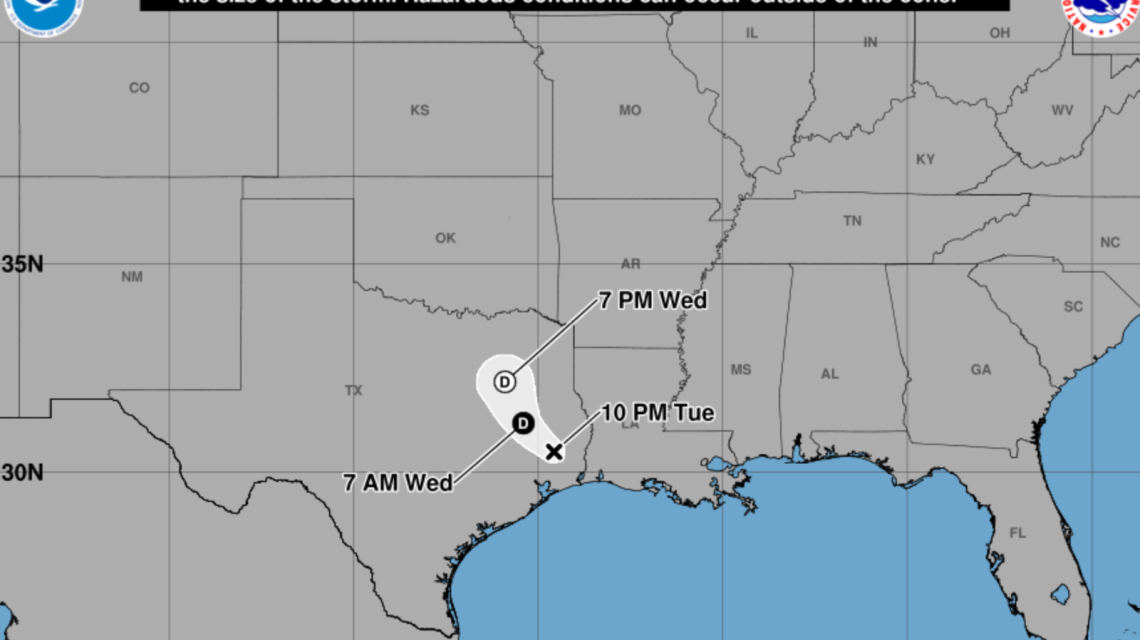
Tropical Storm Edouard has brought significant rainfall and concerns about flooding and travel disruptions in Texas. The storm has weakened to a tropical depression, but forecasters highlight the ongoing risk of widespread rainfall leading to dangerous flash floods throughout the state.
Storm’s Path and Potential Impact
Current models project Edouard moving northward through eastern and central Texas, with the heaviest rains predicted from the upper Texas coast inland. While the storm’s exact path remains uncertain, the models suggest a broad impact across the Gulf Coast into eastern and central Texas, where significant flooding risks are likely.
Focus Shift from Wind to Rain
The National Hurricane Center (NHC) states that while tropical storm force winds may continue near the storm’s center, the primary threat now is heavy rain. This has resulted in warnings of river and flash flooding, especially in urban areas. These warnings extend from the Texas coast through east-central Texas and into parts of southwest Louisiana.
Local Preparations for Flooding
Communities in southeast Texas have been preparing for Edouard’s impacts. In Montgomery County, emergency managers have mobilized equipment and coordinated efforts with state partners. These preparations include securing additional resources, such as rescue boats, due to rising flooding concerns. Schools and some government offices in the area have closed in anticipation. Efforts have been made to place barricades in areas prone to flooding.
Flood Watches Issued
The National Weather Service (NWS) has issued Flood Watches for regions across northeast, east-central, and southeast Texas. In Henderson County and east-central counties like Anderson, Freestone, and Leon, forecasters predict rainfall from 1 to 3 inches through Thursday, with isolated totals reaching 4 to 6 inches. The resulting runoff could flood rivers, creeks, and low-lying areas.
Further south and east, a more extensive Flood Watch includes several counties like Brazos, Chambers, and Harris. Rainfall here may total 3 to 6 inches, with isolated spots facing 10 to 15 inches, mainly along and east of Interstate 45. Intense downpours may bring rain rates of 3 to 4 inches per hour.
Continued Risks and Advisories
Edouard’s remnants are expected to move further inland through Thursday, potentially causing moderate to heavy rain across eastern Texas. Even though the storm is weakening, saturated areas may experience recurring rainfalls.
Emergency officials urge residents to monitor forecasts and respond to flood warnings promptly. They stress not attempting to drive through flooded areas, as water depths can be deceptive and conditions can change quickly.
Texas Governor Greg Abbott’s office addressed preparations in a recent press release dated August 31.
Main Concern from Edouard
For many Texans, the primary concern with Edouard is no longer wind but flooding rain. It poses a significant threat to roads, neighborhoods, and water systems long after the storm has weakened.
 Historical Events in Chicago on October 1st
  Patrick McEnroe Advocates for Collegiate Athletic Reform
  Push for Reparations Faces Challenges and Calls for Strict Eligibility
  Texas Man Arrested for Threatening State Capitol Attack
  The Key Debate Between Xavier Becerra and Steve Hilton: What You Need to Know
  Physicians Urge Senate to Reject FDA Nominee