Earthquake Details
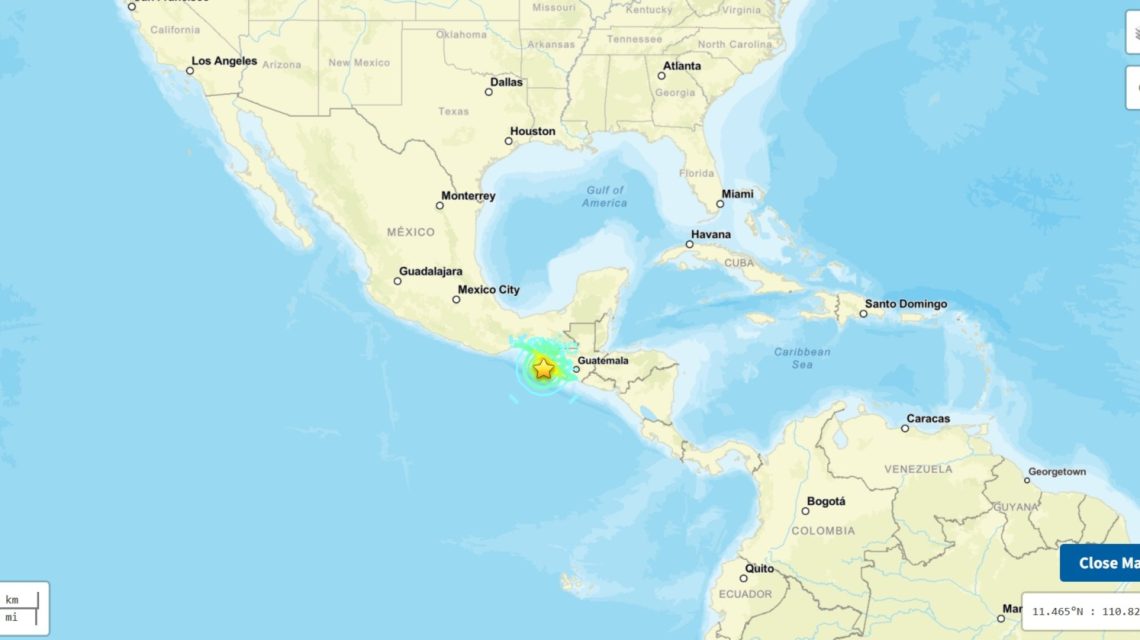
A powerful magnitude 7.3 earthquake struck off the southern coast of Mexico early Friday morning. It caused significant tremors and triggered immediate infrastructure reviews by emergency officials. According to the U.S. Geological Survey (USGS), the quake occurred near the Pacific coast of Chiapas state. The tremor happened at a shallow depth of approximately 9 miles, which typically increases the intensity of shaking and expands its reach.
Seismic Activity Sequence
The main tremor was part of a broader sequence of seismic events in the region. Leading up to and following the main quake, weaker earthquakes occurred, including a magnitude 4.7 quake near Aquiles Serdán, as well as tremors of magnitude 5.1, 5.3, and 6.0 near Puerto Madero. Preliminary USGS data positioned the epicenter about 30 miles southwest of Aquiles Serdán and near Puerto Madero, close to the Guatemala border. The earthquake struck at 8:48 a.m. local time.
Potential Impact
A magnitude 7.0 or greater earthquake is classified as a major event, capable of causing severe to catastrophic damage, especially near the epicenter and in areas with vulnerable structures. According to recent USGS assessments, earthquakes of this magnitude carry potential for serious structural damage, fatalities, landslides, liquefaction, and widespread infrastructure disruptions.
Immediate Response and Safety Concerns
There were no immediate reports of deaths or major damage in the minutes following the earthquake. However, authorities were expected to inspect infrastructure and monitor coastal areas for potential tsunami impacts. Social media videos depicted strong shaking during the earthquake. Although the NWS Tsunami Alerts stated a tsunami was not anticipated in the U.S., a tsunami remained possible given the quake’s characteristics.
“Breaking: Major earthquake offshore of the Mexican/Guatemalan border! This was a magnitude 7.3 thrust quake; the Cocos plate is subducting beneath the North American and/or Caribbean Plate,” noted MyRadar Weather senior meteorologist Matthew Cappucci on X.
Cappucci indicated that the up/down motion of the quake suggested a tsunami threat within 200 miles of the epicenter. Additionally, substantial liquefaction might have occurred, temporarily causing soils to behave like a liquid, resulting in some objects sinking due to reduced crustal stiffness. Significant aftershocks are expected to persist for days.
Historical Context
The September 19, 1985 Mexico City earthquake is often considered one of Mexico’s most deadly and catastrophic disasters. It measured magnitude 8.0–8.1 and inflicted substantial damage across Mexico City, where soft lake-bed sediments intensified the shaking. Estimates of the death toll range between 5,000 to 10,000, with 30,000 people injured and thousands of buildings damaged or destroyed.
Next Steps and Safety Measures
Officials typically advise residents in affected areas to follow local emergency guidance and remain vigilant for aftershocks after such a significant earthquake. Following a magnitude 7.3 quake, aftershocks can continue for several weeks, decreasing in frequency and strength over time. The largest aftershocks usually occur in the initial hours and days but can still happen much later.
 British Police Arrest Man Suspected of Terror Plot
  Activists Push for Nationwide Ban on Child Marriage in the U.S.
  Investigation into Alleged Incident at Cornell University
  Rising Drone Threats Highlight Vulnerabilities in Moldova’s Airspace Defense
  Bolivia Faces Security Test Amid Unrest
  Incident on FlyDubai Flight Raises Security Concerns