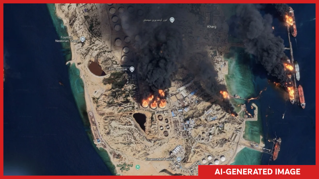
Google recently introduced a feature allowing users to create AI-generated satellite images through its Google Earth platform. However, the company quickly retracted the tool after concerns emerged about the misuse of the technology to generate misleading imagery.
Initial Launch and Immediate Pullback
The new feature was designed to let users create customized satellite imagery by simply zooming into a location on Google Earth and requesting an image of their choice. Bryan Horowitz, a product manager at Google, highlighted its ability to engage user imagination. Despite this, the feature was pulled back when users began sharing potentially harmful images that violated Google’s policies.
Google emphasized that geospatial professionals found the tool useful, but misuse prompted reconsideration. The company is working on stronger safeguards before any possible re-release.
Concerns Over Deepfake Capabilities
Use of the tool raised alarms among experts and analysts who rely on satellite imagery to confirm real-time news or events. The potential to produce and proliferate deepfake satellite images posed significant ethical concerns. Henk van Ess, an open-source researcher, demonstrated the tool’s potential for misuse by generating provocative, fabricated images of various international incidents.
For instance, users could create images showing fires on Iran’s Kharg Island and a flooded U.S. Capitol—events that did not occur but would have significant implications if they were real.
The Importance of Reliable Satellite Imagery
Satellite imagery has long been a reliable source for verifying events, as it is difficult to replicate from terrestrial sources. Institutions using satellite data rely on its authenticity and high resolution, which delivers context and accuracy lacking in other media forms.
Jake Godin, a senior researcher with Bellingcat, noted that while fake satellite images have surfaced in isolated cases, integrating AI tools with satellite imaging could increase the risk of misinformation on a large scale.
Implications and Future Steps
The creation of fake satellite images threatens to undermine public trust and contribute to the spread of misinformation, which tends to circulate widely and rapidly. Google expressed its commitment to tackling misinformation, noting that AI-generated images are marked with a SynthID watermark to ensure transparency.
While Google insists on safeguards, skepticism persists among open-source communities. There is concern over possible developments that could render Google Earth unreliable as a verification tool. The worry lies in the potential for these tools to generate false images that may be used to discredit real ones.
 Trump’s 2024 Campaign Targets Young Men Through Cryptocurrency
  How Modern Windows Improve Home Insulation
  State Department Simplifies Passport Process with Online Applications
  Senate Democrats Block Data Center Bill Over Efficiency Concerns
  Future Cities: Ambitious Projects Aiming for Innovation and Sustainability
  High-Profile Hearing and AI Developments: Key Political Moves