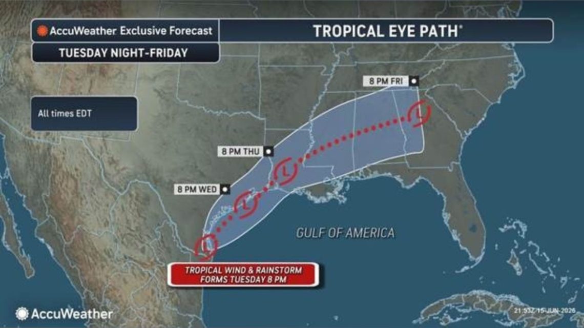
Millions across the Gulf Coast and Lower Mississippi Valley are at risk of severe flash flooding this week. Forecasters are observing a weather disturbance near Texas, which may develop into a tropical storm.
This disturbance is currently producing showers and thunderstorms near the Texas-Mexico border. Forecasters caution that tropical moisture could result in several days of heavy rainfall. If a tropical storm forms, it will be named Arthur, the first name on this year’s list.
Potential Rainfall Impact
The primary concern is the potential for excessive rainfall, which could overwhelm drainage systems. This could trigger dangerous flash flooding and cause rivers to swell rapidly in already saturated areas.
System Near Texas Could Strengthen
An early-morning update from the National Hurricane Center (NHC) on Tuesday noted the presence of a trough of low pressure near the Mexico-Texas border. This has led to a broad area of disorganized showers and thunderstorms.
The system could reemerge over the northwestern Gulf of America today. Environmental conditions there may allow the formation of a short-lived tropical storm later today or on Wednesday, according to the NHC.
The NHC advises preparations for intense rainfall across southern and eastern Texas and parts of Louisiana and Mississippi. This could result in widespread, life-threatening flash, urban, and river flooding. Gusty winds and coastal flooding could also impact areas along the northwestern Gulf Coast.
Flooding Concerns Hold Priority
AccuWeather forecasters have alerted that a ‘tropical rainstorm’ could develop on Tuesday, carrying a significant flooding risk. Dan DePodwin from AccuWeather warns that the repeated rounds of torrential rain could lead to major flash flooding events.
High-Risk Areas
AccuWeather predicts the system might spread heavy rain from eastern Mexico through Texas and parts of the Gulf Coast, eventually moving northeastward. Rainfall rates could hit 2 to 4 inches per hour, particularly in urban areas like Houston, posing a high risk of rapidly rising water.
Possibility of Naming
As of Tuesday morning, flood watches are issued by the National Weather Service across southern and southeastern Texas, much of Louisiana, and southern Mississippi. The Atlantic hurricane season began on June 1 and will last through November, with an expected eight to 14 named storms this year, according to the National Oceanic and Atmospheric Administration.
The NHC will continue monitoring the disturbance and provide regular updates as the situation evolves.
 Rescue Efforts in Venezuela Following Earthquakes
  Texas Women Charged in Stabbing Death of Mother of Five
  Scheffler Stretched to Monday Playoff at Travelers Championship
  Firefighters Battling Severe Wildfires on Colorado-Utah Border Face Tragic Losses
  Skydiving Plane Crash in Eastern France Claims 11 Lives
  Venezuela Hit by Back-to-Back Earthquakes