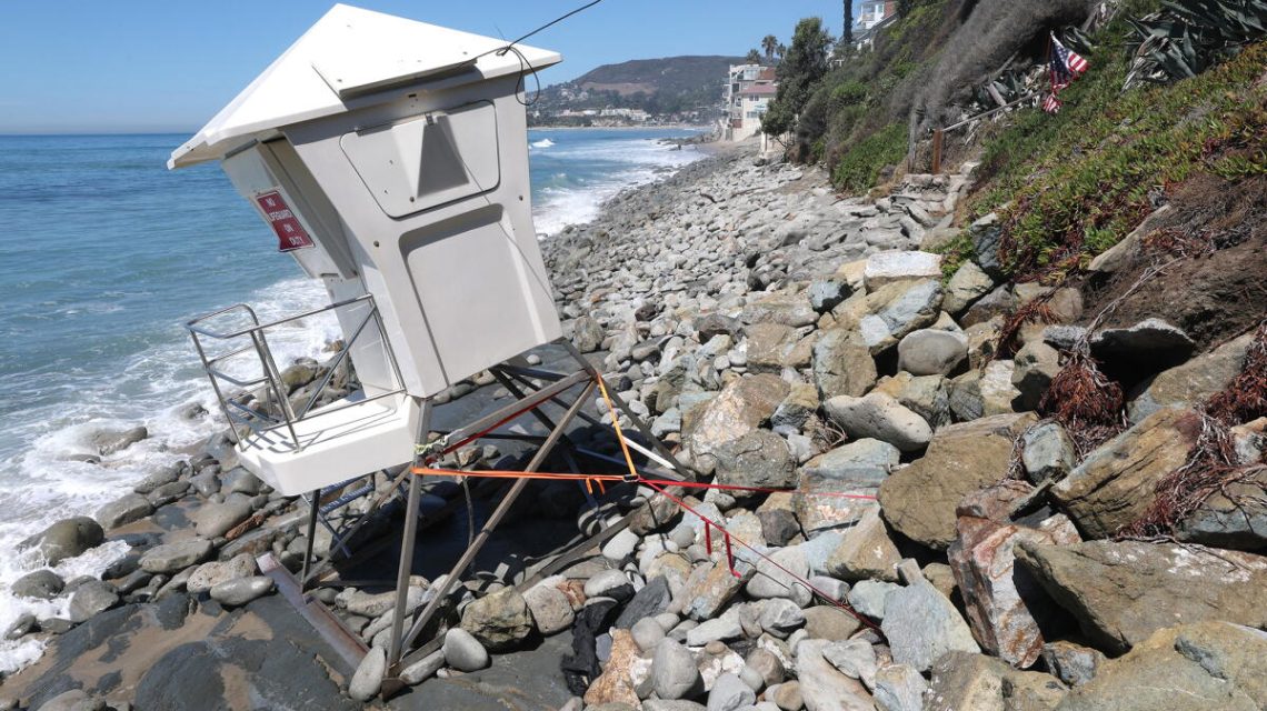
Coastal communities are evaluating the damage inflicted by waves and flooding as Southern California braces for potentially harmful conditions from a coastally trapped Kelvin wave. Homes from south Orange County to Malibu have experienced flooding and severe damage, while erosion has impacted coastal areas from Carlsbad to Long Beach.
Laguna Beach, Dana Point, and Carlsbad have declared a local state of emergency due to coastal erosion and sand loss caused by a south swell resulting from Hurricane Marie. El Niño often leads to a highly active hurricane season in the eastern Pacific, the origin of Hurricane Marie.
Laguna Beach City Manager Dave Kiff shared insights on the widespread damage. He noted that Laguna faced among the most significant damage but highlighted widespread concerns about sand and sand replenishment efforts, which are underway from Newport to Seal Beach and farther south.
Orange County officials have activated their emergency operations center, a necessary step when two cities within the county proclaim a local emergency. Vice Chair Katrina Foley of the Orange County Board of Supervisors stated that serious damage is being encountered, prompting a mobilization of emergency response.
Transportation officials have released a video showing severe erosion threatening train tracks used by Metrolink in San Clemente. The video captures strong ocean waves and crumbling sediment posing risks to the tracks. Metrolink emphasized the severity of the situation.
Carlsbad in San Diego County declared a local emergency as part of efforts to preserve Carlsbad Boulevard, also known as Old Highway 101, from extensive erosion. Homes along Beach Road in Dana Point were flooded by waves earlier this week.
Upcoming Threats from Kelvin Waves and El Niño
An El Niño-influenced phenomenon, known as the coastally trapped Kelvin wave, is approaching the U.S. West Coast from Mexico. Experts predict more damaging storms this winter, with forecasters estimating a 75% chance for an El Niño stronger than any since 1950. The National Oceanic and Atmospheric Administration’s Climate Prediction Center reports a 98% likelihood of El Niño being very strong for the three months ending in December.
Understanding Kelvin Waves
Kelvin waves are at the core of El Niño, a climate pattern influencing global weather. Coastally trapped Kelvin waves have long been identified, characterized by following a coastal boundary with the shoreline to their right in the Northern Hemisphere.
Recent computational advances have enabled scientists to model and track Kelvin waves in real-time. Researcher Dillon Amaya noted the current occurrence of one of the largest El Niños, which correlates with some of the largest coastally trapped waves recorded.
As El Niño evolves, typical equatorial trade winds weaken or reverse, allowing warm water to move east from the western equatorial Pacific towards Peru, driven by Kelvin waves. These equatorially trapped Kelvin waves remain near the equator and split upon reaching South America, with one part heading north toward California.
Impact on Sea Levels
Kelvin waves become coastally trapped, elevating sea levels, increasing ocean temperatures, and pushing cold waters deeper. They can raise sea levels by 6 to 12 inches for extended periods, increasing flood risks and beach erosion when combined with storms.
Homes on the Long Beach Peninsula experienced high tides and wave impacts related to Hurricane Marie’s remnants.
Wave Timing
The coastally trapped Kelvin wave is currently off Mexico’s west coast and is expected to enter the Gulf of California shortly. It may take roughly two weeks to reach Southern California, with arrival anticipated in early October. The wave travels extensively, with a path of roughly 15,500 miles from the western equatorial Pacific to Alaska over 120 days.
Expected Effects
This wave will not be visible to swimmers or boaters but is likely to increase California’s sea levels by about 6 inches for an extended duration. This rise could exacerbate the impact of storms on the already damaged coast.
Researcher Jonathan Warrick of the U.S. Geological Survey highlighted the recent harm houses suffered during high tides, exacerbated by hurricane-related swells. Elevated water levels can cause substantial damage.
California has seen approximately a foot of sea level rise over 125 years due to human-driven global warming and polar ice-cap melting, coupled with recent unusual high tides.
 Swiss Glaciers Show Effects of Ice Loss Amid Global Warming
  Climate-Resistant Rock Glaciers: Hidden Water Resources
  Senators Reach Bipartisan Agreement on Permitting Reform
  Experts Warn of Critical Period for the Colorado River
  Future Cities: Ambitious Projects Aiming for Innovation and Sustainability
  Supreme Court Case Suncor vs. Boulder: Implications for Accountability in Climate Change