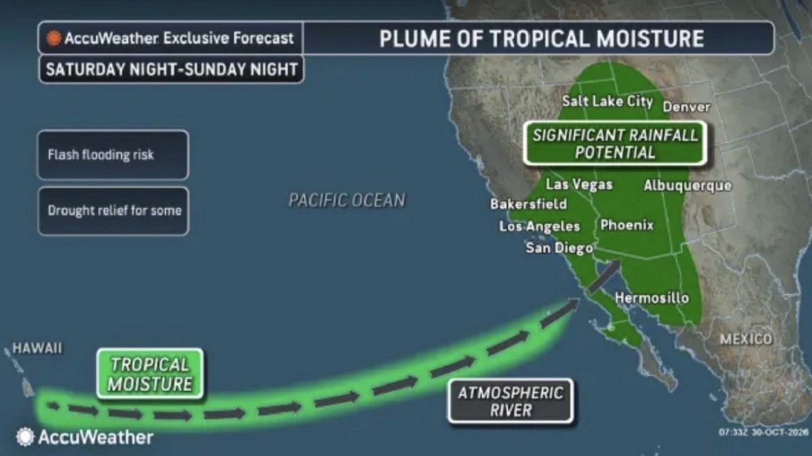
A developing weather system is drawing tropical moisture toward the southwestern United States, posing a risk of heavy rain, flash flooding, and mountain snow over Halloween weekend. States recently hit by storms could face renewed flooding threats. Southern California may also experience significant rainfall, depending on storm systems’ interactions, AccuWeather meteorologists report.
The atmospheric phenomenon could create a corridor of concentrated water vapor, known as an atmospheric river, transporting moisture from tropical areas to the West Coast. When stretched from Hawaii to the western U.S., it could result in a ‘Pineapple Express,’ a term for atmospheric rivers carrying moisture-rich air toward North America.
These systems bring much-needed rain to drought-stricken regions but can also cause dangerous conditions when precipitation falls rapidly. Heavy rain can overwhelm drainage systems, elevate river levels, and trigger flash floods. Mountainous areas may face substantial snowfall, with steep slopes and previous wildfire zones vulnerable to mudslides and debris flows.
Potential Impact Areas
AccuWeather’s map forecasts potential precipitation across various regions, pinpointing sites likely to experience heavy rain during Halloween weekend and early next week. Two primary storm systems are pushing tropical moisture toward the western U.S.: one from Alaska and another near the coast of Washington state. Tropical Rainstorm Olana near Hawaii is also contributing to moisture movement.
AccuWeather meteorologists predict that these storms and their moisture will likely stay partly separated along the Pacific coast. In Southern California, this would result in limited rainfall, possibly less than an inch in major cities like Los Angeles, San Diego, and Palm Springs. However, south and west-facing mountain slopes may receive up to three inches.
In a less probable scenario, the storms could merge earlier, forming a larger, slower-moving system near the coast and resulting in heavier rainfall. This could heighten flash flooding risks in Southern California.
Southwest’s Renewed Flood Threat
Parts of the Southwest face a significant rainfall threat, particularly in Arizona, Utah, New Mexico, and Colorado. Flash flooding, debris flows, and river surges are potential hazards from late this weekend into early next week. Rainfall may range from 1 to 2 inches across much of this area, while central Arizona, southwestern Colorado, and Utah could see 2 to 4 inches. AccuWeather’s Local StormMax predicts up to seven inches.
This additional rain is worrisome for regions that have had recent heavy precipitation. The San Juan Mountains in northern New Mexico and southern Colorado saw 5 to 10 inches of rain last week, worsening flooding and record streamflows. Further rain could exacerbate flooding, affecting cities like Phoenix and Flagstaff in Arizona, Durango in Colorado, and Farmington in New Mexico.
The broader weather system will likely bring showers to the Pacific Northwest and snow to high elevations in the Rockies, including parts of Montana, Idaho, Wyoming, Colorado, and Utah.
Forecasts will remain under observation as meteorologists refine predictions regarding timing, paths, and potential rainfall.
 Record Low Hydropower Output in the Southwest
 Data Centers Face Challenges in Vernon, Los Angeles
 Rams Captured Relaxing in Residential Area
 Global Climate Finance and the Developing World: A Turning Point
 Hidden Plastics in Everyday Items
 The Final Journey of the SS United States