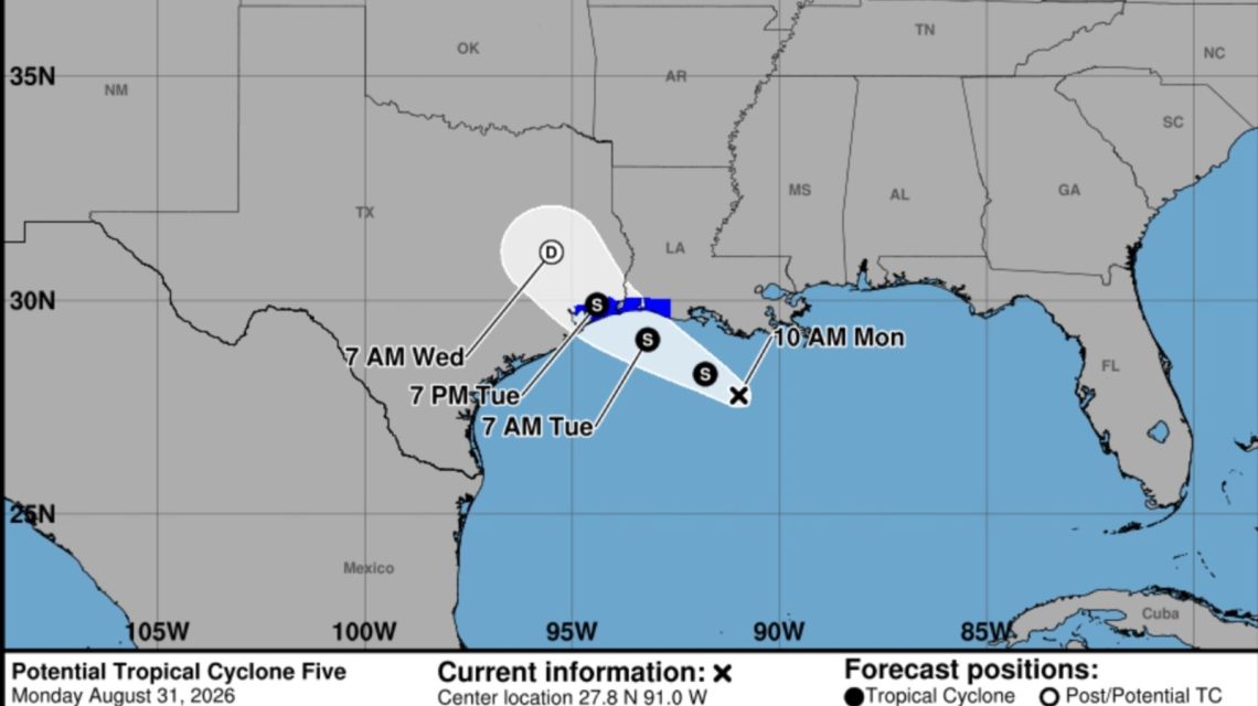
A tropical rainstorm in the northern Gulf Coast is poised to bring significant rains, flash floods, and potential travel disruptions in parts of Texas and Louisiana this week. Meteorologists indicate that while the storm is unlikely to escalate into a major wind event, substantial rainfall is a primary concern as it nears the coastline.
The National Hurricane Center has initiated advisories on Potential Tropical Cyclone Five. This disturbance is currently active in the northwestern Gulf, generating 35 miles per hour sustained winds. Tropical storm warnings are now in place for sections of the upper Texas and southwestern Louisiana coastlines, following the system’s west-northwest movement at approximately 5 mph.
Forecast models suggest that the disturbance might intensify briefly before reaching land. According to AccuWeather, there is a possibility it could transition into a tropical depression or tropical storm before arrival. The next available name on the Atlantic list is Edouard. However, no major strengthening is predicted.
Impact on Coastal Areas
Initially, the heaviest rain is predicted to hit coastal Louisiana, gradually affecting southeastern Texas, including the Houston metro area. Animated maps from windy.com illustrate substantial rainfall over the forthcoming days across coastal Texas and Louisiana. Some regions may receive as much as 9 inches of rain.
“PTC Five is expected to produce rainfall totals of 3 to 6 inches with maximum totals of 9 inches for parts of the Upper Texas Coast inland through east-central Texas, with 2 to 3 inches for Southwest Louisiana,” the NHC elaborated. “This rainfall could produce flash flooding, especially in low-lying and urban areas.”
AccuWeather anticipates widespread rainfall accumulations of 1 to 2 inches along the Louisiana coast and into eastern Texas. A rain corridor with 2 to 4 inches is expected near Houston and southeastern Texas. Some spots could record much higher totals due to persistent thunderstorms in the same areas. AccuWeather’s Local StormMax forecast projects that isolated areas might receive up to 12 inches of rain through Wednesday.
Timeframe and Regional Effects
Rain and thunderstorms are set to intensify across Louisiana on Monday and subsequently move into coastal Texas by Monday night and Tuesday. Houston and its neighbor areas are likely to experience the heaviest rain late Monday into Tuesday, which will heighten the likelihood of flooded roads and travel issues during busy commuting hours.
Satellite visuals from windy.com show the storm nearing the coast by late Monday morning. Even regions not witnessing the highest rainfall amounts could face intense downpours. These can quickly exceed drainage capacity, causing standing water in low-lying zones. Officials stress the importance of avoiding driving on flooded streets due to uncertain water depths and possible hidden road damage.
Secondary Wind Impact
Wind is anticipated to have a lesser impact. The storm might produce localized gusts near the coast and within stronger storms, along with rough surf and perilous conditions for small crafts in the northern Gulf. However, widespread destructive winds or significant coastal water rises are not currently expected.
As the system progresses inland over southeastern Texas, it is expected to rapidly weaken and dissipate. Nevertheless, tropical moisture may continue across the Gulf Coast during much of the week, supporting additional rain and thunderstorms from Texas, across the central Gulf Coast, and into Florida. This implies that localized flooding might remain a concern even after the storm system fades.
 Swiss Glaciers Show Effects of Ice Loss Amid Global Warming
  TikTok Couple Arrested for Alleged Arson in West Virginia
  21-Year-Old University of Georgia Student Survives Eight-Story Fall
  Texas Authorities Arrest Suspect Over Potential Capitol Attack
  Arizona State University Hockey Incident Leads to Coach’s Administrative Leave
  Senate Vote on Data Center Electricity Cost Legislation