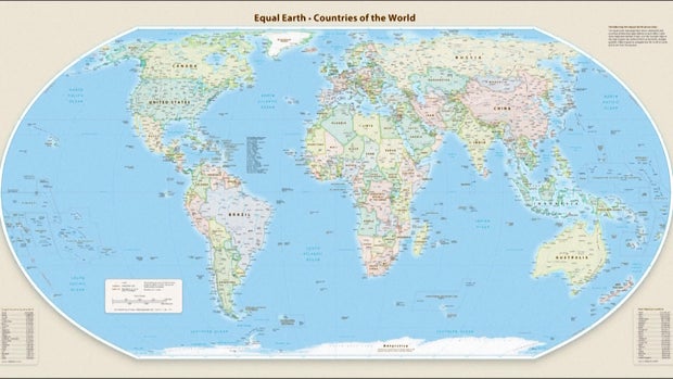
The United Nations General Assembly has endorsed the Equal Earth map projection, which gives a more accurate representation of Africa’s size. This move is the outcome of a campaign initiated by African countries and advocacy groups, aimed at correcting historical inaccuracies in map representations.
A resolution sponsored by Togo and strongly supported by African Union members saw 164 member states voting in favor of the change. The United States opposed it, while Serbia, Estonia, Georgia, Lithuania, Moldova, and Ukraine abstained. Despite the opposition, the resolution encourages global institutions to adopt the Equal Earth projection over the traditional Mercator map.
The Equal Earth map adjusts country sizes to reflect true proportions, showing Africa as 14 times larger than Greenland.
The U.N.’s resolution does not impose a ban on the Mercator projection but promotes the adoption of the more accurate Equal Earth projection. Togo’s Foreign Minister Robert Dussey emphasized the impact of maps on education and global perceptions.
Africa No Filter, a leading advocate for the resolution, stressed the importance of accurate maps in education, media, and digital platforms. Support echoed globally, with figures like French Foreign Minister Jean-Noël Barrot remarking that correcting map inaccuracies is a step towards truth.
Originally designed for sea navigation by Flemish cartographer Gerardus Mercator, the Mercator map distorted land masses, enlarging areas near the poles and shrinking continents like Africa and South America. The Equal Earth projection introduced in 2018 better reflects Earth’s curvature, portraying continents accurately in size.
Geographers like Mark Monmonier from Syracuse University argue the traditional Mercator map’s usefulness is confined to navigation. He stated, “Outside of that very narrow navigation application, there is no point in using it.”
The endorsement of the Equal Earth map is seen as a powerful move for educational and institutional accuracy in representing world geography.
 British Police Arrest Man Suspected of Terror Plot
  Activists Push for Nationwide Ban on Child Marriage in the U.S.
  Investigation into Alleged Incident at Cornell University
  Rising Drone Threats Highlight Vulnerabilities in Moldova’s Airspace Defense
  Bolivia Faces Security Test Amid Unrest
  Incident on FlyDubai Flight Raises Security Concerns