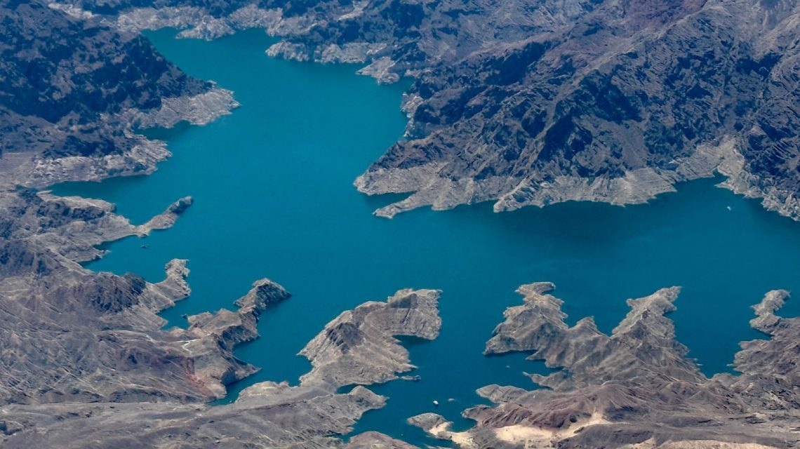
Federal projections suggest a faster decline in Lake Mead’s water level. A recent study by the U.S. Bureau of Reclamation (USBR) predicts the reservoir could drop to 1,015.77 feet above sea level by July 2027. The USBR’s updated 24-month study shows a steeper decline than last month’s forecast, which estimated the lake would be at 1,020.76 feet by July next year.
This decrease is linked to the ongoing drought conditions affecting the Colorado River network. This system supplies water to approximately 40 million people in the Western U.S. and supports over 5 million acres of farmland. The declining water levels heighten concerns about water and electricity availability at key reservoirs.
A USBR spokesperson emphasized the need for new guidelines and procedures, stating, “Recent projections highlight the ongoing vulnerability of the Colorado River system and emphasize the urgent need to develop new guidelines and establish updated procedures.” As of Tuesday, Lake Mead held 7,454,257 acre-feet of water, only 29% full and 47% of the average for this date, according to USBR data.
What the Projections Indicate
The USBR’s 24-month study provides a detailed hydrological analysis and operational forecasts for the Colorado River system for the next two years. The latest figures predict Lake Mead could fall to 1,011.74 feet by May 2028.
The agency stresses that these are projections and subject to change as actual hydrological conditions evolve. Despite this, concerns about power generation persist due to adverse forecasts for the Colorado River system.
“The study continues to rely on operational assumptions using soon-expiring operating guidelines, projecting Lake Powell reaching minimum power pool in spring 2027,” the USBR stated. “This reflects the system’s ongoing vulnerability and the need for updated operational tools.”
Scientists warn of a potential “system crash” due to the imbalance between water supply and demand in the Colorado River system.
Which States Rely on the River?
The river is crucial for several states, including Colorado, New Mexico, Utah, and Wyoming in the Upper Basin, and Arizona, California, and Nevada in the Lower Basin. Efforts to negotiate new water-sharing agreements continue, as existing guidelines are set to expire. However, a unified solution remains elusive.
Satellite images have documented the dramatic decline in Lake Mead’s water levels over 25 years. Images from Landsat 7, a United States Geological Survey and NASA mission, show a noticeably smaller reservoir in 2024 compared to 1999.
 Tribes Seek Water Rights Amidst Disputes Over Colorado River
 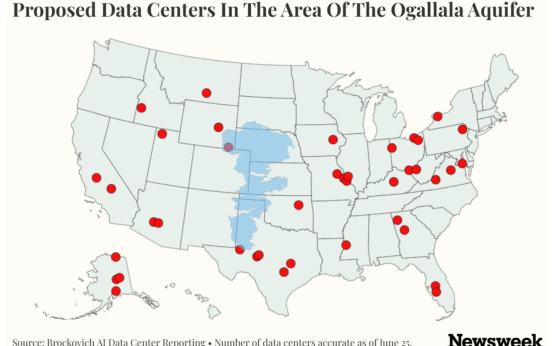 The Impact of AI Data Centers on Groundwater Resources in the Great Plains
  France’s Heat Wave Causes Spike in Deaths Amidst Europe’s Record Temperatures
  Europe and U.S. West Struggle with Severe Heat and Fire Threats
  Ian Somerhalder’s Journey from Hollywood to Farming and Environmental Advocacy
  Hong Kong: The World Leader in Skyscrapers