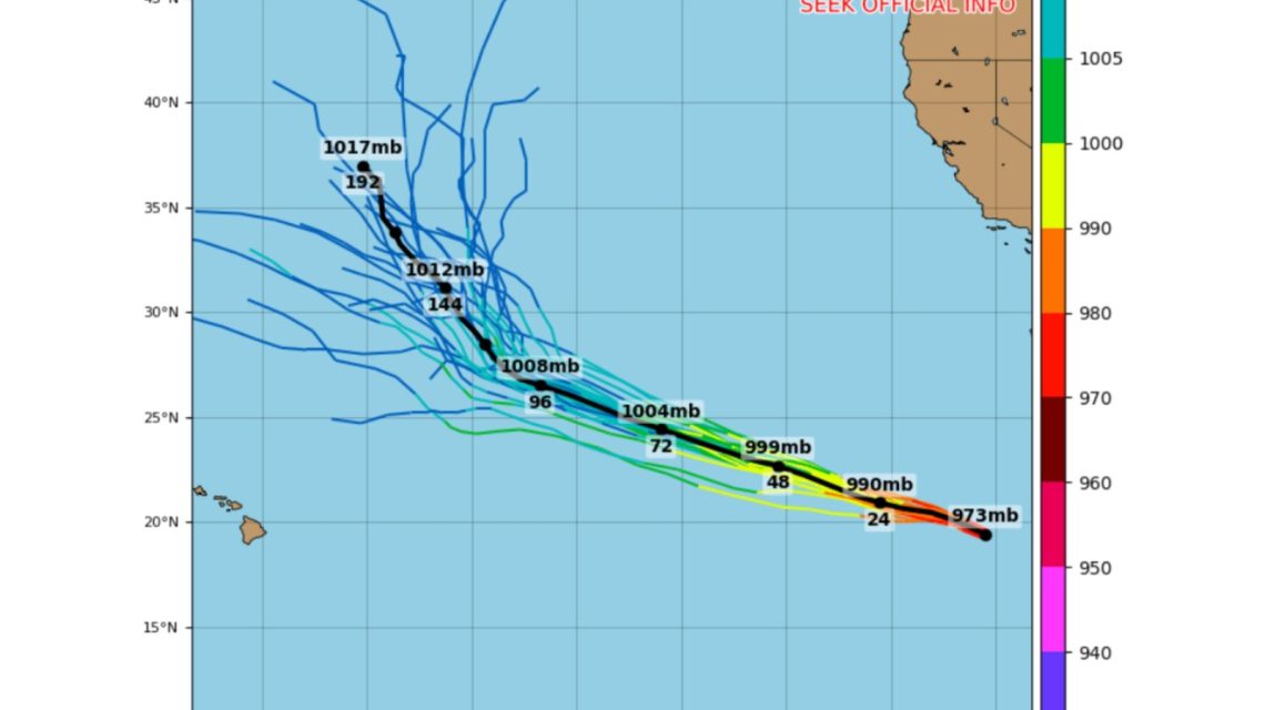
Hurricane Genevieve gained attention as the first Category 5 storm in the eastern Pacific since 2024. Forecasters predict a weakening trend in the upcoming days as it moves west-northwest.
Genevieve began as a tropical depression on July 24, far off Mexico’s coast. By that evening, it became a tropical storm. The following day, it advanced to hurricane status and rapidly intensified on July 26, reaching Category 4 with winds at 155 miles per hour. By Sunday night, winds increased to 160 mph, marking it as a Category 5 hurricane, according to AccuWeather. “While eastern Pacific Major Hurricane Genevieve poses no direct threat to land, it has become the most powerful hurricane in the waters surrounding North and Central America this year and the first Category 5 hurricane since Kristy in 2024,” noted Alex DaSilva, an AccuWeather hurricane expert.
By Thursday morning, Genevieve had weakened to a 100-mph, Category 2 hurricane. The National Hurricane Center (NHC) expects further weakening in the coming days. It was moving at 9 miles per hour, with a slight increase in speed expected soon. Maximum sustained winds were 100 miles per hour, with higher gusts, and the storm may become post-tropical by the weekend.
Genevieve’s rapid intensification was notable by eastern Pacific standards. It became a Category 5 storm in about two days, a pace rivaling significant hurricanes in the region. Although it did not match Hurricane Patricia’s record in 2015, Genevieve stands among the more intense hurricanes of the last decade. The first Category 5 since Kristy (2024) shows the rarity of such storms, even with favorable El Niño conditions.
The NHC noted that swells from the hurricane impact parts of southern California and the Baja California Peninsula. “These swells will persist for the next several days, causing life-threatening surf and rip current conditions,” it reported. DaSilva advised that no direct impacts are expected in Mexico, though rough surf and rip currents will continue on Mexico’s west coast and Southern California throughout the week.
Safety Recommendations for Southern California Beachgoers
- Check local beach and surf advisories before entering the water.
- Swim only at beaches with lifeguards and stay within designated areas.
- Avoid the ocean if red flags or hazardous surf warnings are posted.
- If caught in a rip current, stay calm, float, swim parallel to the shore before returning.
- Keep children and inexperienced swimmers away from rough surf and shoreline break zones.
AccuWeather anticipated “numerous” storms and hurricanes in both the eastern and central Pacific this year, influenced by El Niño. This pattern often results in warmer sea surface temperatures, increasing activity, while reducing Atlantic activity.
“While lower wind shear due to El Niño plays a role in rapid intensification, warm sea-surface temperatures and high Ocean Heat Content also contribute,” DaSilva stated. AccuWeather expects 17 to 22 named storms in the eastern Pacific, including nine to 13 hurricanes and four to eight major hurricanes.
The National Oceanic and Atmospheric Administration’s Climate Prediction Center forecasted an above-normal hurricane season with a 70% chance. Their estimates included 15 to 22 named storms, nine to 14 hurricanes, and five to nine major hurricanes.
Eastern Pacific Hurricane Season Storm Names
The NHC provided the 2026 storm names: Amanda, Boris, Cristina, Douglas, Elida, Fausto, Genevieve, Hernán, Iselle, Julio, Karina, Lowell, Marie, Norbert, Odalys, Polo, Rachel, Simon, Trudy, Vance, Winnie, Xavier, Yolanda, Zeke.
For inquiries, contact Newsweek editors Matthew Robinson and James Debens.
 Swiss Glaciers Show Effects of Ice Loss Amid Global Warming
  Climate-Resistant Rock Glaciers: Hidden Water Resources
  Senators Reach Bipartisan Agreement on Permitting Reform
  Experts Warn of Critical Period for the Colorado River
  Future Cities: Ambitious Projects Aiming for Innovation and Sustainability
  Supreme Court Case Suncor vs. Boulder: Implications for Accountability in Climate Change