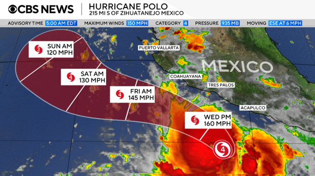
Hurricane Polo intensified rapidly off the southwestern coast of Mexico on Tuesday. The storm strengthened into a Category 5 hurricane, which poses a threat of life-threatening flooding to parts of Guerrero and Michoacán, according to the National Hurricane Center.
Polo achieved Category 5 status on Tuesday morning after maximum winds increased from 150 mph to 160 mph. The National Hurricane Center indicated that additional strengthening might occur through Wednesday.
Located about 220 miles south of Zihuatanejo in Guerrero, and roughly 360 miles south-southeast of Manzanillo in Colima, Polo was moving eastward at 6 mph near Mexico’s Pacific Coast.
The center warned, “Rainfall may produce life-threatening flooding and mudslides, especially in areas of steep terrain.” A tropical storm watch was issued from Tecpan de Galeana to Manzanillo. Meteorologists forecast possible tropical storm conditions within these areas in the next 48 hours.
Forecasters project Polo will follow its current path and then turn sharply northwest on Tuesday night and Wednesday, bringing the hurricane’s core closer to Mexico’s southwestern coast. While the storm is expected to remain offshore, it will likely deliver heavy rainfall and could cause dangerous flooding and mudslides, particularly in steep terrain along the coast.
Some regions in Guerrero and Michoacán might see 4 to 8 inches of rain, with certain locations potentially receiving up to 12 inches by Thursday. Coastal areas of Oaxaca, Colima, and Jalisco might also experience 3 to 6 inches of rainfall through Thursday.
 Swiss Glaciers Show Effects of Ice Loss Amid Global Warming
  Climate-Resistant Rock Glaciers: Hidden Water Resources
  Senators Reach Bipartisan Agreement on Permitting Reform
  Experts Warn of Critical Period for the Colorado River
  Future Cities: Ambitious Projects Aiming for Innovation and Sustainability
  Supreme Court Case Suncor vs. Boulder: Implications for Accountability in Climate Change