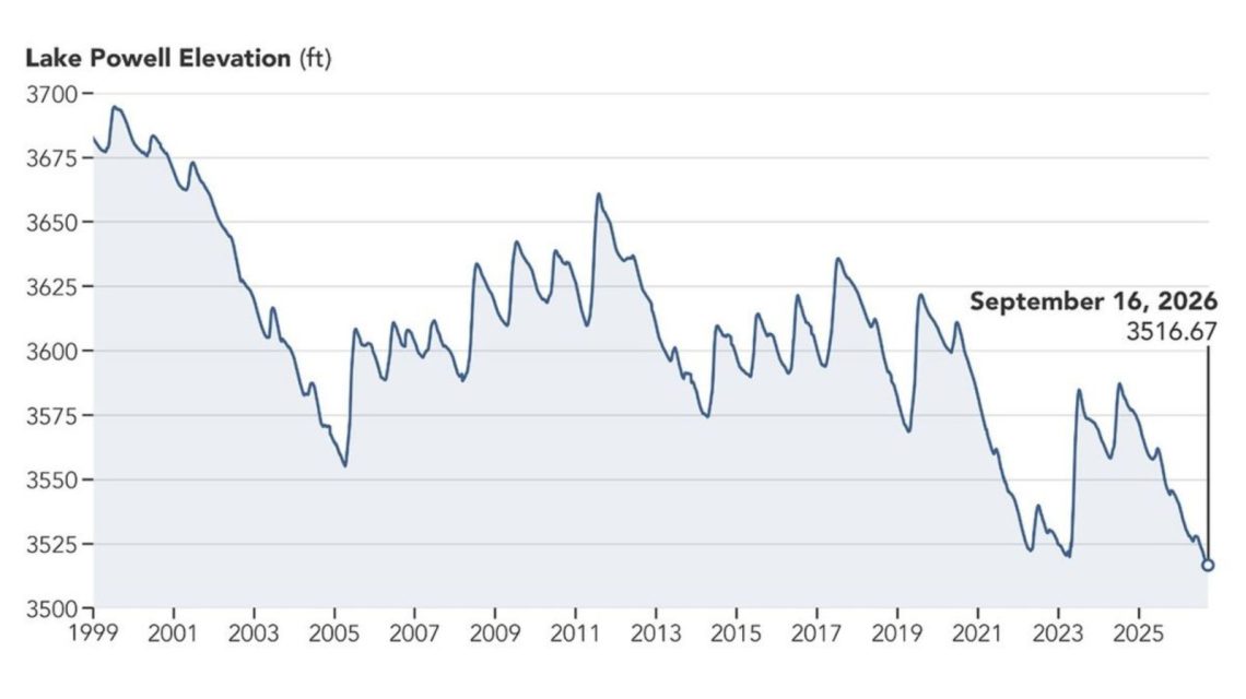
Newly released satellite images reveal a dramatic decline in Lake Powell’s water levels over the past nine years. These images compare the lake near Glen Canyon Dam between September 1, 2017, and September 10, 2026. A prolonged drought has led to the reservoir reaching unprecedented low levels.
Water Levels Over Time
NASA highlighted the reservoir’s substantial drop in water levels. In 2017, Lake Powell registered one of its highest levels of the preceding decade. Fast forward to September 10, 2026, and you see a significantly reduced water level. At that time, Lake Powell’s level was 3,517.24 feet, which followed its previous record low of 3,519.92 feet reached in April 2023.
The Importance of Lake Powell and the Colorado River
Lake Powell ranks as the second-largest reservoir in the United States. It lies along the drought-impacted Colorado River, a crucial waterway stretching about 1,400 miles. The river is vital for seven states: Arizona, California, Colorado, Nevada, New Mexico, Utah, and Wyoming, in addition to Mexico.
This river supports municipal water for tens of millions and is essential for hydropower, recreation, fish, wildlife, and millions of acres of agriculture.
Record Lows for Major Reservoirs
The release of these satellite images coincided with both Lake Powell and Lake Mead reaching record lows in August. The Bureau of Reclamation manages these reservoirs, noting the unprecedented winter snowpack decline in the Colorado River Basin during 2025-2026.
Sarah Porter, director of the Kyl Center for Water Policy at Arizona State University, mentioned to Newsweek that these low levels are discouraging but not unexpected. She noted that while the reservoirs might see some recovery after heavy snowfall, it is unlikely to stabilize the reservoirs long-term.
Federal water managers announced steps in April to address the declining water levels in Lake Powell. These included releasing water from the upstream Flaming Gorge Reservoir and reducing downstream releases from Lake Powell to Lake Mead.
The Bureau of Reclamation warned that without substantial intervention, the falling water levels in Lake Powell might jeopardize hydropower production at the Glen Canyon Dam.
Predicting Future Water Levels
Recently released federal projections suggest a potential rise in Lake Powell’s water level by around 40 feet over the next two years. However, the projections also indicate that Lake Mead could drop by a similar amount.
According to the Bureau of Reclamation’s ‘most probable’ 24-Month Study in September 2026, assuming 6 million acre-feet of water is released from Lake Powell in the 2027 operating year, Lake Powell could rise to 3,558.44 feet by June 2028. Meanwhile, Lake Mead might decrease to 998.40 feet by August 2028.
 Senators Reach Bipartisan Agreement on Permitting Reform
  Experts Warn of Critical Period for the Colorado River
  Future Cities: Ambitious Projects Aiming for Innovation and Sustainability
  Supreme Court Case Suncor vs. Boulder: Implications for Accountability in Climate Change
  Hawaii Faces Impact of Record El Niño Through Recent Hurricanes
  Efforts to Save the Endangered American Red Wolf