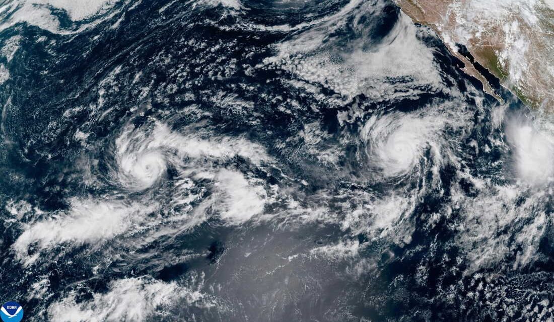
The National Oceanic and Atmospheric Administration (NOAA) has released a satellite image showing three storms in the Pacific Ocean as of Thursday, September 24, 2026. Tropical Storm Nolo is located south of Hawaii, Hurricane Polo is off the coast of Mexico, and Hurricane Odalys is positioned between them.
This hurricane season has been exceptional for the Atlantic and Pacific Oceans, but for distinct reasons. The Pacific has experienced 18 hurricanes and a total of 41 named storms by this point, which is unexpected. In contrast, the Atlantic Ocean has yet to see any significant hurricanes as of September 25, marking a first in over a century. Only seven named storms, all classified as tropical storms of lesser intensity, have been reported.
Professor Gabriel Vecchi of Princeton University describes the scenario as a sharp contrast between the two regions. The Pacific is highly active, while the North Atlantic remains unusually calm. A significant factor is El Niño, a climate pattern that impacts oceanic and atmospheric conditions differently across these regions. El Niño tends to reduce hurricane activity in the Atlantic but increases it in the Pacific.
The Impact on Hawaii
Hawaii is currently feeling the effects of these weather patterns. According to the National Hurricane Center, Hurricane Nolo is projected to bring heavy rain and possible flooding to Hawaii over the weekend. This follows two earlier threats from Hurricane Lala in August and Hurricane Lowell in early September.
Photographer Ryanna Fry captured an image of the storm clouds in Kona, Hawaii, as Hurricane Nolo approached on Friday, September 25, 2026.
Explaining El Niño’s Role
Experts point to the record-breaking El Niño as a key reason for this year’s unusual conditions. El Niño is characterized by elevated water temperatures in the Pacific Ocean, near the equator. These warmer waters fuel hurricanes, leading to more frequent and powerful storms. They also affect global weather patterns. In the North Atlantic, El Niño enhances wind shear, making hurricane formation more challenging by disrupting storm systems.
This year’s El Niño is notably intense. Pacific water temperatures are reaching unprecedented levels, and the peak of the phenomenon is yet to come. Brian McNoldy from the University of Miami notes this year’s El Niño is surpassing expectations, impacting both oceans markedly.
Climate Change and El Niño
Researchers are exploring why some El Niño events are more intense. Some studies suggest climate change might contribute to their strength, though the evidence remains inconclusive. Regardless, El Niño’s potential effects are well-documented. It can push global temperatures higher while altering precipitation patterns, causing some regions to experience more rain and others to face drought.
Paul Roundy from the University at Albany highlights that Hawaii might see more storms, and Central America might face droughts and fires. El Niño could also result in a wetter winter in parts of the Southwestern U.S., exacerbating flood risks in drought-stricken areas.
Beyond El Niño, climate change continues to influence global weather. McNoldy emphasizes that climate change is a constant influence on oceanic and atmospheric conditions, amplifying the occurrence of extreme weather events worldwide.
 Swiss Glaciers Show Effects of Ice Loss Amid Global Warming
  Climate-Resistant Rock Glaciers: Hidden Water Resources
  Senators Reach Bipartisan Agreement on Permitting Reform
  Experts Warn of Critical Period for the Colorado River
  Future Cities: Ambitious Projects Aiming for Innovation and Sustainability
  Supreme Court Case Suncor vs. Boulder: Implications for Accountability in Climate Change