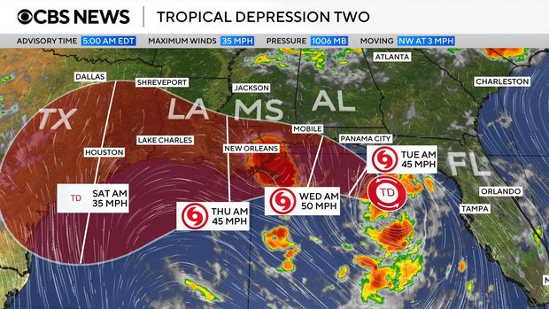
Tropical Storm Bertha formed on Monday, impacting the Gulf Coast with significant rainfall. As the second named storm of the Atlantic hurricane season, it is located south of the Florida Panhandle, featuring maximum sustained winds of 40 mph, as reported by the National Weather Service. The storm is advancing west-northwest at approximately 3 mph.
The storm’s projected path has been mapped, initially identified as Tropical Depression Two before evolving into Tropical Storm Bertha. According to the track, the storm will progress along the Gulf Coast, moving from the Panhandle and approaching the New Orleans area, then reaching eastern Texas later in the week.
The National Weather Service anticipated a slow northwestward movement overnight, subsequently shifting west-northwest or west. The forecast suggests that the storm will closely interact with the northern Gulf coast in the upcoming days.
A Tropical Storm Watch has been declared for regions from the Ochlockonee River in Florida to the Jefferson/Plaquemines Parish border in Louisiana. Meanwhile, a Storm Surge Watch covers from the Alabama/Florida border to the Mississippi River’s mouth.
Forecasters predicted rainfall accumulation up to 8 inches in several locations. This rainfall is expected throughout the week along the Gulf Coast and adjacent inland areas, from western Florida to the Texas coast. Areas in Alabama, Mississippi, and Louisiana will also encounter the rain, potentially causing flash flooding.
Bertha may lead to storm surges, with water levels rising up to 4 feet in certain segments along the Gulf Coast. This development occurs weeks after Tropical Storm Arthur, the first named storm of the 2026 hurricane season, which struck the Gulf Coast of Texas in June.
 Failed Execution in Tennessee Sparks Controversy
  Trump Announces $100 Checks for Seniors to Aid Medicare Part B Premiums
  TSA Discovers Spent Smoke Grenade at Watertown Airport
  Hockey Player’s Family Criticizes ASU’s Response and NHL Player Honors Late Father
  Teen Left in Critical Condition After West Ridge Shooting
  Death of Kenan ‘Ken’ Urker, Partner of Gypsy Rose Blanchard