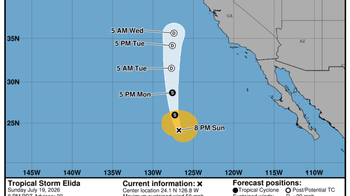
This week, Southern California is bracing for a significant heat wave paired with hazardous high waves along its coastline. These conditions arise due to high pressure advancing from the east and the atypical trajectory of Tropical Storm Elida in the Pacific Ocean. The storm threatens Southern California beaches with hazardous surf and strong rip currents.
Heat Wave Outlook
The National Weather Service in Oxnard indicates the heat wave is set to kick off on Tuesday, lasting seven days, with a potential for ‘major heat risk’ by the weekend. Affected areas include the Inland Empire, inland Orange County, San Diego County valleys, and the deserts and mountains. On Wednesday, temperatures could reach 105 degrees in Lancaster and range from 85 to 103 degrees in other places like Canoga Park, Santa Clarita, Covina, downtown L.A., Santa Barbara, and Long Beach.
Later in the week, temperatures may exceed 100 degrees in the Inland Empire and parts of San Diego County’s valleys, and could surpass 110 in the deserts, according to Sebastian Westerink, a meteorologist from the weather service’s San Diego office. Critical fire weather conditions might occur from Tuesday through Monday due to hot, dry winds in interior areas.
High Surf Warning
Tropical Storm Elida, originating near southern Mexico, now moves northward, causing high surf. Dangerous swimming conditions are expected, particularly on southern-facing beaches. Waves could rise to 4-8 feet, as already seen in Orange County, with some sets even higher.
Another system, Tropical Storm Fausto, might bring additional elevated swells later this week. Unlike typical storms which follow warmer waters westward, Elida’s northern path is an anomaly. Meteorologist Rachel Kennedy noted the storm will soon weaken in cooler waters near California, leaving only remnants.
Elida will stay offshore, but its tail end brought moisture to the San Francisco Bay Area on Sunday. Expect light rain and isolated lightning, with chances highest Monday and early Wednesday. Beautiful sunsets might result from these storm remnants.
Impact of Marine Heat Wave
The warmth and humidity experienced lately are partly due to a marine heat wave off Southern California’s coast. Current sea surface temperatures are near record highs for this time of year. Meteorologist Lamont Bain mentioned warm ocean temperatures significantly affect the air, making it muggier.
The National Oceanic and Atmospheric Administration notes these sea temperatures rival those seen during past strong El Niño years. However, the current marine heat wave isn’t yet impacted by El Niño. It remains prominent just off Southern California and much farther offshore.
Health and Safety Precautions
During this heat wave, Carol Ciliberti from the weather service office in Oxnard emphasizes avoiding outdoor work if possible. Take frequent breaks if outside, and stay in air-conditioned areas. Walk pets during cooler parts of the day, and never leave children or pets in parked cars.
Historical Context
California recently recorded its hottest January-through-June period since 1895. Neighboring states experienced similar records. Climate scientist Zachary Labe attributes these prolonged heat periods to human-caused climate change.
 Ireland vs Israel: Nations League Clash Amidst Political Tension
  Supreme Court’s New Term Tackles Climate Liability and Key Legal Battles
  Tick Crisis on Martha’s Vineyard: A Growing Health Threat
  Colorado’s Emissions Regulation and Its Broader Implications
  The Threat of Melting Glaciers: A Call to Action
  Collapse of Hawai’i’s Hōlei Sea Arch Amidst Storms