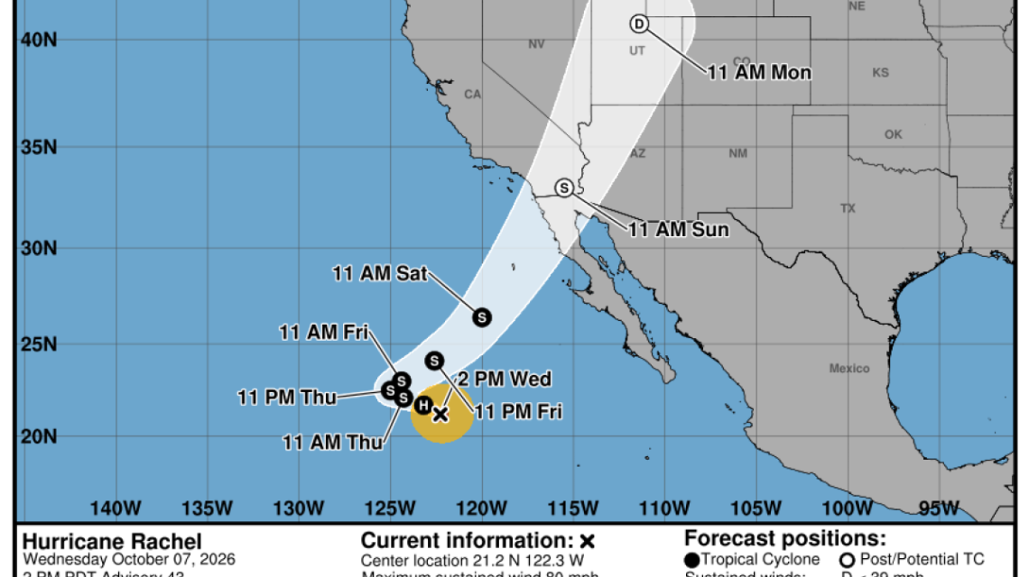
Hurricane Rachel, currently situated in the Pacific Ocean, is expected to increase the risk of coastal flooding in Southern California. This event could bring significant rainfall to the region over the weekend and into early next week. Meteorologists highlight that south-facing beaches like Long Beach Peninsula, Catalina Island, and the coastline from Malibu to Ventura are particularly susceptible to flooding due to Rachel and an exceptionally active, El Niño-influenced hurricane season.
Rising Sea Levels and Flood Risk
A Kelvin wave, another phenomenon related to El Niño, has raised sea levels by 6 to 12 inches, further increasing the flood threat to California’s coast. Ryan Kittell, a meteorologist with the National Weather Service in Oxnard, anticipates peak flooding risks on Sunday. Kittell noted, “We’re likely to witness significant beach erosion, especially on Sunday, affecting already vulnerable areas.” Tidal levels in Southern California are expected to exceed the norm by 1 to 1.5 feet due to El Niño’s contribution to unusually warm ocean temperatures, according to Kittell.
Potential Impact of Hurricane Rachel
Although Rachel was a Category 1 hurricane mid-week, forecasts predict it will weaken as it approaches Southern California. A complex weather scenario involves two atypical low-pressure systems interacting with Rachel’s remnants to form a new system impacting the area, Kittell explained. While the probability of the system retaining tropical storm strength upon reaching Southern California is low, rainfall is anticipated.
Rain and Storm Predictions
Kittell indicated that rain chances peak from Sunday night through Monday, with a 70% to 90% probability of rainfall in L.A. and Ventura counties between Saturday and Tuesday. For the 2XU Long Beach Marathon on Sunday, there is a 40% to 50% chance of rain. Expected rainfall amounts range from a quarter to three-quarters of an inch, with higher amounts in mountainous regions.
Forecast for Wind and Surf
Sunday is expected to be windy, with gusts between 20 to 35 mph. Strong rip currents and waves could make swimming dangerous. There is a slight risk of strong winds and thunderstorms coinciding with high surf and rip currents, heightened by high tides and the Kelvin wave.
Understanding Kelvin Waves
These waves, propelled by El Niño, elevate sea levels as they move along coastlines. Michael Jacox from NOAA explains that these waves closely follow the shoreline. Dillon Amaya from North Carolina State University mentioned that sea levels might remain elevated for months, as additional El Niño-related waves travel from the tropics.
The Impact of El Niño
NOAA’s Climate Prediction Center reports an 83% chance of this El Niño being historically strong. Past strong El Niños have resulted in increased rainfall in Southern California, as seen in the wet winters of 1982-83 and 1997-98. This occurrence of El Niño often affects global weather through warm ocean waters and atmospheric changes.
Heat Wave Subsiding
The recent extreme heat in Southern California is set to taper off by the weekend, with temperatures decreasing significantly. However, Thursday will still see high temperatures, with heat warnings in effect for many areas. Recommendations remain to limit outdoor activities to cooler parts of the day and seek air-conditioned spaces.
 Balancing Development and Conservation: The Endangered Species Act Debate
  The Rise of Bokashi Fertilizer Among Zambian Farmers
  Architects Spotlight Housing Challenges in Light of Climate Change and AI Concerns
  Scaling Advanced Nuclear Power to Meet Energy Needs
  Supreme Court’s New Term Tackles Climate Liability and Key Legal Battles
  Tick Crisis on Martha’s Vineyard: A Growing Health Threat