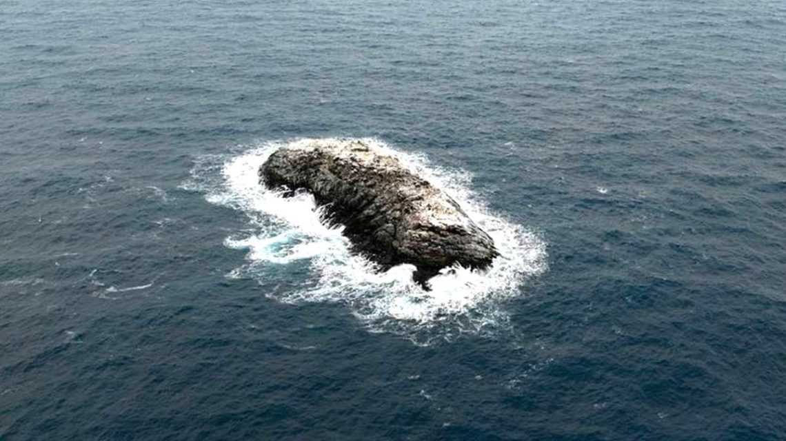
Researchers have identified an island in the northwestern Weddell Sea, previously mistaken as a danger zone, and successfully mapped it for the first time. The announcement came from the Alfred Wegener Institute (AWI), a German polar research center. The discovery was made during an expedition using the AWI’s icebreaker, the Polarstern.
While initially focused on studying sea ice decline, researchers had to pause due to severe weather conditions. They sought refuge on Joinville Island, where they noticed the unidentified landmass. Initially perceived as a dirty iceberg, upon closer examination, the team realized they had found an island.
Simon Dreutter, a bathymetry data engineer at AWI, mentioned that nautical charts indicated unexplained hazards in the area, but their nature was unknown. After inspecting the coastlines and noticing the ‘iceberg,’ Dreutter remarked, “on closer inspection, we realized that it was probably rock.”
Subsequent exploration involved using drone imaging and echo sounding technology to survey the island, confirming it rises more than 50 feet above the surrounding water. This marks the first complete survey and recording of the region.
The island measures roughly 426 feet in length and about 164 feet in width, protruding approximately 16 meters (52 feet) from the water. Despite its discovery, the official identity of the island remains pending, awaiting the formal naming process by the Scientific Committee on Antarctic Research (SCAR).
Officials remain uncertain about why the area was marked as a hazard. It may be due to uncharted shoals on the seafloor, leading to sudden changes in water depth over short distances. The AWI representative noted, “Many areas, especially inshore and nearshore, can be considered white spots or gaps in the map.”
The exploration process also highlighted that less than a quarter of the Weddell Sea is comprehensively charted, presenting opportunities for further discoveries. While satellite data provide low resolution modeling for many regions, especially nearshore areas, numerous features remain obscured.
The Antarctic environment still holds potential for new landform discoveries, as emphasized by the AWI representative who commented on the rarity of such findings. Although technology facilitates satellite observation, substantial portions of Antarctic waters are yet to be fully mapped.
 Rare Dinosaur Fossil Discovery in Antarctica
  The History and Impact of U.S. Science Funding: Lessons from Lewis and Clark
  NASA’s Bold Mission to Save the Aging Swift Telescope
  Firefighters Killed in Utah-Colorado Border Wildfire
  The Historical Insights of Tree Rings
  Astronomers Discover Fluffy Exoplanets with Low Density